


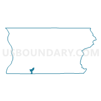
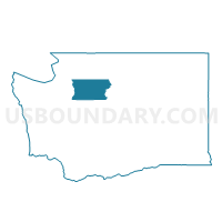
High Bridge Voting District, Snohomish County, Washington
About
Outline

Summary
| Unique Area Identifier | 688644 |
| Name | High Bridge Voting District |
| County | Snohomish County |
| State | Washington |
| Area (square miles) | 5.82 |
| Land Area (square miles) | 5.80 |
| Water Area (square miles) | 0.02 |
| % of Land Area | 99.73 |
| % of Water Area | 0.27 |
| Latitude of the Internal Point | 47.81684600 |
| Longtitude of the Internal Point | -122.00668650 |
Maps

Graphs
Select a template below for downloading or customizing gragh for High Bridge Voting District, Snohomish County, Washington


Neighbors
Neighoring Voting District (by Name) Neighboring Voting District on the Map
- Alder Springs Voting District, King County, WA
- Cathcart Voting District, Snohomish County, WA
- High Rock Voting District, Snohomish County, WA
- Lost Lake Voting District, Snohomish County, WA
- Monroe 1 Voting District, Snohomish County, WA
- Monroe 4 Voting District, Snohomish County, WA
- Park Place Voting District, Snohomish County, WA
- Tualco Voting District, Snohomish County, WA
- Welch Voting District, Snohomish County, WA
Top 10 Neighboring County Subdivision (by Population) Neighboring County Subdivision on the Map
- Seattle East CCD, King County, WA (544,255)
- Maltby CCD, Snohomish County, WA (47,151)
- Monroe CCD, Snohomish County, WA (29,402)
- Sultan CCD, Snohomish County, WA (14,286)
Top 10 Neighboring Place (by Population) Neighboring Place on the Map
Top 10 Neighboring Unified School District (by Population) Neighboring Unified School District on the Map
- Northshore School District, WA (122,684)
- Snohomish School District, WA (51,850)
- Monroe School District, WA (37,606)
- Riverview School District, WA (19,315)
Top 10 Neighboring State Legislative District Lower Chamber (by Population) Neighboring State Legislative District Lower Chamber on the Map
- State House District 1, WA (147,265)
- State House District 39, WA (143,154)
- State House District 45, WA (136,432)
Top 10 Neighboring State Legislative District Upper Chamber (by Population) Neighboring State Legislative District Upper Chamber on the Map
- State Senate District 1, WA (147,265)
- State Senate District 39, WA (143,154)
- State Senate District 45, WA (136,432)
Top 10 Neighboring 111th Congressional District (by Population) Neighboring 111th Congressional District on the Map
Top 10 Neighboring Census Tract (by Population) Neighboring Census Tract on the Map
- Census Tract 323.11, King County, WA (5,837)
- Census Tract 522.09, Snohomish County, WA (5,029)
- Census Tract 538.01, Snohomish County, WA (3,639)
- Census Tract 521.13, Snohomish County, WA (3,006)